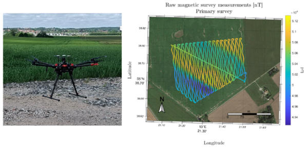
The DroneSOM project has hired several Ph.D. and post-doctorate students to work on the research. Among the teams involved, the 3D inversion group is developing imaging software that can convert large-scale drone electromagnetic, gravity, and magnetic data into 3D electrical conductivity models, density models, and magnetization models. This software is mainly developed by Dr. Longying Xiao and Dr. Cedric Patzer under the supervision of Associate Professor Jochen Kamm. The team is basing the software on the finite-element method with locally refined octree meshes for modeling and a Gauss-Newton optimization approach for the inverse problem. The code will be optimized for MPI parallelization to run on large-scale compute clusters.
DTU Space is currently developing an optimized gravimetry software through the efforts of PhD student Bjørnar Dale. This software uses the direct method, and once completed, will be used alongside existing processing techniques for airborne gravimetry campaigns. To achieve this, DTU Space has collaborated with a new postdoc candidate, Biao Lu, who is part of the gravity group at the institution.
The Technical University of Denmark (DTU) organizes a three-week course on drone-based gravity and magnetic surveying every year. The course is open to PhD and master’s students, as well as anyone who is interested and can participate through an open university. The course will take place between June 6th and June 26th, 2024.
More information about the enrollment can be found here: https://lnkd.in/dJvdS-AE

The students will gain an understanding of the theoretical background of magnetic and gravity data and be able to discuss engineering design criteria for drone-based technologies and sensors relative to magnetic and gravity surveying. They will learn the importance of real-time and post-processing GNSS positional precision of data and survey platforms. They will design, plan, and evaluate magnetic and gravity surveys for ground, drone, and airborne operations, and operate selected magnetic and gravity sensor systems. This will enable them to carry out basic processing of magnetic and gravity data collected in the field and understand the quality and resolution of the data collected. They will also perform gridding, plotting, and various enhancement techniques of data for optimal visualization of data and evaluate photogrammetry surface models to reduce non-uniqueness in the interpretation of magnetic and gravity data. This will allow them to carry out simple modeling of magnetic and gravity anomalies and discuss the pros and cons of drone, airborne, and ground-based magnetic and gravity survey campaigns/data, including satellite data. They will report the results of the data collected in the field to potential industrial clients after the course.
Students have provided positive feedback, stating that:
“The course provides a better understanding of how to collect and use magnetic and gravity data optimally.”
“I gained broad knowledge and practical experience on how to optimally plan a survey, taking into account geological features, terrain, weather, etc. Additionally, the course provides a good understanding of how various post-processing methods can be used to enhance information in magnetic data sets.”
“The course is closely related to the methods used in the industry in terms of post-processing, planning, and instrumentation.”
More information about the 2024 course can be found here: https://lnkd.in/eyJ4AH_S
