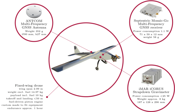
Instruments for measuring gravity have traditionally been large and heavy – about the size of a washing machine with a weight approaching 100 kg. The actual gravity sensor can be relatively small and compact, but since it measures only along one direction in space, an entire apparatus had to be built around the sensor in order to keep its sensitive axis aligned with the local plumb line, i.e. along the direction of the gravity vector.
In recent years, an alternative system has been used for airborne gravity surveys with great success – namely navigation-grade Inertial Measurement Units (IMUs). Instead of a large platform, this system utilizes a set of three perpendicular accelerometers and gyroscopes that measure accelerations and angular velocity at a very high rate (e.g. 300 Hz or more). From such observations, the full acceleration vector with orientation can be computed post-mission. The system currently in use by DTU Space is about the size of a shoebox and weighs around 8 kg.

Although being rather heavy in terms of drone applications, this system is within the limit of what is possible and this is what we aim to show within the DroneSOM project. In order to optimize the expected flight endurance, a drone is being custom-made for the equipment to be used for the gravity survey. This will ensure that the weight stays as low as possible while adhering to the target regulation requirements. Concurrently the technology used in IMUs is developing fast, with the prospect of even smaller and lighter systems in the near future.
The gravity sensor, essentially being an accelerometer, will measure accelerations originating both from gravitational attraction and from the movement of the drone. In order to retrieve the gravitational signal, these kinematic accelerations must thus be accounted for. The movement of the drone is monitored via the Global Navigation Satellite System (GNSS), from which the accelerations of the drone can be derived. The rather small platform with respect to traditional aircrafts, might pose a much more challenging environment in this respect. We will therefore make sure that the GNSS equipment is of the best quality possible, linking to new available satellite networks including the European Global Navigation Satellite System (GALILEO).
